Before I talk about another possible scenario on the Flood of Noah, some background is in order about the Christ-centered model for early Genesis. It is a very different way to understand the same text. That a model which is Christ-centered is a "very different" view of early Genesis ought to be a red flag to Christians that the common view in error. The church got a lot right. They got Jesus Christ right. They got the gospel right. They got, miraculously, the Trinity right. But they have gotten early Genesis very wrong. They don't understand the text and where it points to those things they have gotten right: Christ, the Gospel, and the Trinity. Before it hardly mattered. Now it does.
In the Christ-centered model, Adam is not the sole genetic father of humanity but rather a figure of Christ (Rom. 5:14) formed to bring the line of Messiah into the world. He need not be the first man, except in the sense that Christ is the second man- that is as a stand-in for the human race. He could have come long after humanity got its start. The flood is aimed only at the clan of Adam, which is not the same as the race Adam. Thus, the descendants of Adam are another example of the "chosen people" theme which finds its highest manifestation in the Household of Faith.
Yes, that is too much to take in at a glance and I don't expect people who have not had the background to follow all of it. After all, all the videos I linked to above just scratch the surface of the contents of a 342 page book. And it gets worse. Most people with an opinion on it place the garden of Eden far to the south of the Tigris and Euphrates, but if we have the region where the ark landed right, it is likely that the southern location for Eden is wrong. A great deal of evidence points to an origin for civilization via domestication of plants and animals on the northern reaches of the Tigris and Euphrates rivers. This fits well with the Christ-centered model's view of Adam and the Garden.
Mesopotamia has a lot of flood stories with common elements to the account in Genesis because that's where the clans of Noah journeyed to after the flood. It wasn't because Mesopotamia is where the flood had its greatest impact. Mesopotamia got a "glancing blow" from the flood of Noah because it was down-hill from the true flood target area. Even still, the effect was enormous, but still manifested as local floods along the Tigris and/or Euphrates rivers as they drained portions of the highlands. The whole of Mesopotamia was not covered. The flood deposits found by Sir Woolley at Uruk may be an example.
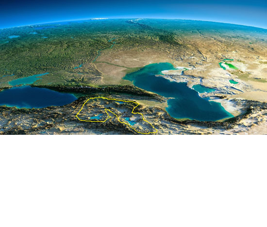
I don't know where the Garden of Eden was, or where the clan of Adam took up residence once they were expelled. But the most likely region based on the epicenter of plant and animal domestication events is somewhere in the southern band of this picture below....

The three large highland lakes shown there are Lake Van (left), Lake Sevan, and Lake Urmia (lower right). This is a very mountainous region. But if you will look closely (you may have to click on the image and open it in another tab) you will see a sort of "bowl". The high mountains have even higher mountains on all sides, except for a few narrow drainage points. I have outlined this region in yellow below. The picture is not as big so you may need to toggle between the two in order to see it.
Where could water be trapped in a highland local flood scenario?
Some may be thinking "but they would have seen the mountains on the horizon if they were trapped in such an area." That's one of the misconceptions about the ark I discuss in this video. The text indicates that they did not have an unobstructed view of the horizon. They may have only been able to see what was immediately around their ship.
Here is a short video showing a Bronze age site in this region and from there zooming the horizon where you can see the mountains and understand how the inhabitants would be in a "bowl" or at least a "pan". You can see how flood waters coming in would be restricted from going out and though it looks small on the map, even a tiny part of that area is huge in life.
Here is a short video showing a Bronze age site in this region and from there zooming the horizon where you can see the mountains and understand how the inhabitants would be in a "bowl" or at least a "pan". You can see how flood waters coming in would be restricted from going out and though it looks small on the map, even a tiny part of that area is huge in life.
People have been looking for the evidence of a global flood, and even a flood which covered the whole of Mesopotamia, for a long time. They have not found such evidence and its time to consider the possibility that this is because the evidence is not there. They have the wrong place. They need to look north, to a flood in a place that is surrounded by high mountains with very few and narrow river canyons through which such a flood could drain.

Please "like" and "share".
No comments:
Post a Comment
Note: Only a member of this blog may post a comment.